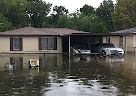
Realtor.com announced Monday that the online real estate listing portal will start displaying flood data on every property, including a flood-risk score from First Street Foundation, a nonprofit research and technology group.
Each home — including both for sale and off-market properties — will be scored between 1 to 10 on its risk of flooding over a 30-year mortgage, and will also display its flood zone determined by Federal Emergency Management Agency (FEMA).
“Historically, determining a property’s flood risk was an onerous process — in some cases, potential buyers would have no idea a property was in a flood zone until it was flagged by the mortgage company before closing, or in some cases not at all,” Leslie Jordan, senior vice president of product at realtor.com, said in a statement. “By surfacing this information upfront, consumers can avoid surprises and have all the information they need to make informed decisions and feel confident about the home buying process.”
The flood risk model displayed on each home was developed by First Street Foundation, which released public-facing flood data in June. The model assesses the risk to the individual property both today and in the future.
It incorporates local areas not currently mapped by FEMA and assesses the risk from four different types of flooding events: riverine, rainfall, storm surge and tidal sources. FEMA classifies 8.7 million properties as being at substantial risk of flooding, while the First Street Foundation’s model identifies 14.6 properties at the same level and predicts that number will pass 16 million by 2050.
“Integrating Flood Factor on realtor.com provides millions of current and future homeowners with a comprehensive, accessible understanding of a property’s flood risk due to a changing environment over the life of a 30-year mortgage,” Matthew Eby, executive director of First Street Foundation, said in a statement. “By democratizing access to this information, First Street Foundation is helping homeowners protect what is likely their largest, most valuable asset: their home.”
The property will also include the FEMA flood zone in which the property is located, which is the official public source for flood hazard information that’s produced in support of the National Flood Insurance Program. A property in a designated flood hazard area is defined as having flood, mudflow or flood-related erosion hazards and is required to have purchased flood insurance.
By arming existing homeowners and potential buyers with the information, consumers can better make decisions to implement cost-saving, protective measures, as well as mitigate future risks.


